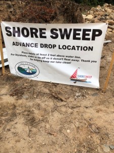
Advance Drop sites are now open!
The Shore Sweep advance drop locations are now open and will remain open until the evening of Friday, 9/14/18. You can leave bagged trash or large debris at these sites during this time and we will send a crew to pick up at the Shore Sweep event on 9/15. Please be sure to leave the debris high enough or tied off so that it doesn’t float back out into the water. Look for the banners posted and leave the debris close to the banner. Please do NOT use these sites for trash drop off other times of the year outside of our authorized advance drop location window.
There are eight advance drop locations. The lake map coordinates are from the Atlantic Mapping Recreation and Fishing Guide for Lake Lanier.
Map coordinate J-7, closest buoy marker 1SM, old beach at Shady Grove Park
Map coordinate H-7, closest buoy marker 4YD, Beaver Ruin Road shoreline area
Map coordinate L-3, closest buoy marker 2SC, Gwinnett Park
Map coordinate N-9, closest buoy marker 14, Gaines Ferry Islands
Map coordinate L-18, closest buoy marker 33, Keith’s Bridge Island
Map coordinate M-24, closest buoy marker 49, Old Dawsonville Highway road bed near DNR regional office and Martin Docks
Map coordinate M-28, closest buoy marker 2WC, unnamed island in Wahoo Creek
Map coordinate D-21, closest buoy marker 21C, east side of Nix Island in the area of Athens Boat Club